|
Section 5:
Land and Infrastructure
14.
Transport (Great Britain)
This
section considers the transport infrastructure
in the regions and devolved administrations.
Two indicators are used:
a)
Mode of transport to work
b)
Average speed and vehicle flows on roads.
Travel
to work patterns
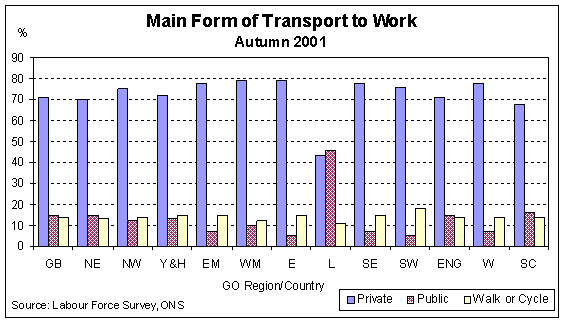
Table
14(a) and Chart 14(a) provide data on the main
mode of transport used to travel to work.
During autumn 2001 it was estimated that 74
per cent of people travelling to work in Great
Britain used private transport (car, van,
minibus, motorcycle or bicycle). The chart
illustrates how people in London make much
more use of public transport than the
residents of other regions, with nearly 46 per
cent of people travelling to work by public
transport. Overall, nearly 11 per cent of
people in Great Britain walked to work during
autumn 2001.
Chart 14(a)
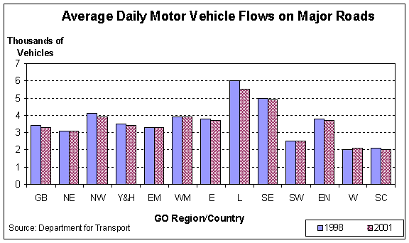
 Tables
14(b) and 14(c) cover two further aspects of
transport: the average speed and daily vehicle
flows on the major roads of England.
These estimates cover motorways and 'A'
roads only.
In showing this information it is
recognised that conditions within regions are
often affected by conditions in other regions.
For example, congestion in one region can
often spill over to the roads in another. The
figures show that average speeds in England
increased by just over 5 km/hour in between
1998 and 2001 with the largest regional
increase in London at nearly 8.5 km/hour.
Traffic flows remained broadly stable across
Great Britain during the same period, although
traffic flows on major roads within London did
fall significantly between 1998 and 2001.
Chart 14(b)

Chart 14(c)
15.
Industrial Property and Office Rental
Costs
This
is a measure of property costs by region.
The estimates are based on a sample of
different locations within each region of
Inland Revenue property valuations.
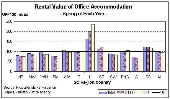
Chart
15(a) illustrates the capital cost of
industrial/warehouse units, with Chart 15(b)
detailing average rental costs for Type 1
office accommodation.
Descriptions of the types of industrial
accommodation used in this section are
provided in Definitions.
Table 15(a) details the capital value index of industrial property while Table 15(b) contains the rental cost of office accommodation. The relatively high cost of industrial and office accommodation in London and the South East is evident from both the tables and charts. Increases have been particularly marked in London between Spring 2001 and Spring 2002, with a rise of 32 points in the index of Type 1 office accommodation. The indices for all other areas of the UK have fallen back or remained stable during the last year. The Index of (Type 3) Industrial property value indicates a different pattern over the latest year. The relative growth in the value of industrial accommodation in London has been far less marked (5 points on the UK = 100 index) with rises also occurring in some other regions. Based on the UK index, between 1998 and 2002 the greatest growth in the relative value of industrial accommodation was in Northern Ireland, with a rise of 28 points.
Chart 15(a)
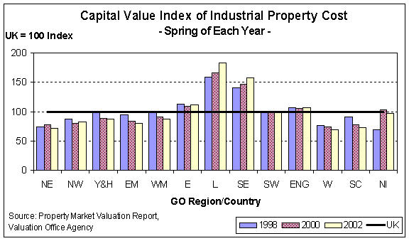
Chart 15(b)
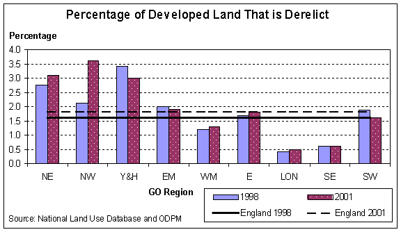
 16. Re-Use of Vacant and Derelict LandTable
16 provides estimates of the proportion of
previously developed land that is derelict or
vacant as well as the proportion of land that
has potential for redevelopment. Chart 16
illustrates the proportion of derelict land in
1998 and 2001. For the definitions of vacant
and derelict land refer to the Definitions
section.
In
1998 Yorkshire and Humberside had the highest
proportion of developed land that was vacant
(2.8 per cent) in addition to the highest
percentage of developed land that was derelict
(3.4 per cent). By 2001, this pattern had
changed with the North East having the highest
percentage vacant land (at 3.3 per cent of
total stock) and the North West the highest
proportion of derelict land (3.6 per cent –
an increase of around 1.5 percentage points on
the 1998 figure).
The
lowest percentage of developed land left
unused and/or derelict during both 1998 and
2001 was in London (less than 1 per cent of
the total stock during this time). Further,
during these years London had the lowest
proportion of land with redevelopment
potential of any English region.
The
profile of land redevelopment for London is
unsurprising, with commercial pressures
driving up land values and speeding up the
redevelopment / recycling of unused, derelict
or land with redevelopment potential.
Chart 16
Home - Search - Site Map - Contact Us |