Two indicators are used to assess the transport infrastructure in the regions and devolved administrations:
a) Mode of transport to work
b) Average speed and vehicle flows on roads.
Travel to work patterns
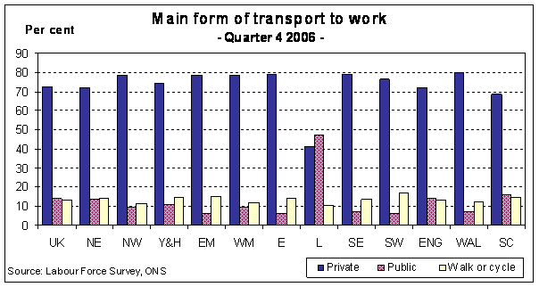
Table and Chart 15(a) provide data on the main mode of transport used to travel to work. During Quarter 4 2006 nearly three-quarters of people travelling to work in GB used private transport (car, van, minibus or motorcycle), while more than 10 per cent walked to work. The chart illustrates that people working in London make much more use of public transport than those working in other regions, with nearly half of all those who work in London using public transport to get there.
Chart 15(a)
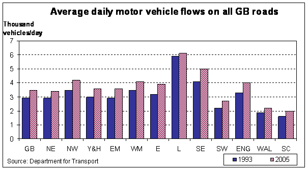
Tables 15(b) and 15(c) cover two further aspects of transport: the average speed of traffic on major English roads (motorways and 'A' roads only) and daily vehicle flows on all roads in Great Britain. In showing this information it is recognised that conditions within regions are often affected by conditions in other regions. For example, congestion in one region can often spill over to the roads in another. The figures show that average speeds in England increased by 3.7 km/hour between 1998 and 2003, with the largest regional increase in the East of England at 7.9 km/hour. Traffic flows increased in every region in Great Britain between 1993 and 2005, with the biggest increase in the South East of almost a thousand more vehicles a day.
Chart 15(b)
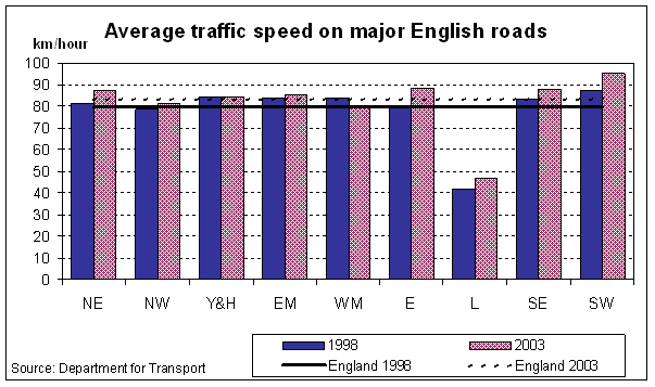
Chart 15(c)
This is a measure of property costs by region. The estimates are based on Inland Revenue valuations from a sample of different locations within each region. From 2004, the publication of these data has changed from April and October to January and July of each year. Due to this transition, there are no figures for October 2003.
Chart and Table 16(a) illustrate the capital value index of industrial/warehouse property, with Chart and Table 16(b) detailing the average rental costs index for Type 1 office accommodation. Descriptions of the types of industrial accommodation used in this section are provided in Definitions.
The ‘London and South East’ differential for industrial property compared with the UK as a whole increased by 20 per cent between April 1998 and January 2007. Relative office rental costs in London have fluctuated more than elsewhere, the index peaking at 239 per cent of the UK average in April 2002, then falling back before rising again to 202 per cent by January 2007.
Relative office rental costs increased by 20 per cent in the North East between April 1998 and January 2007. while Northern Ireland showed a relative fall of 17 per cent.
Chart 16(a)
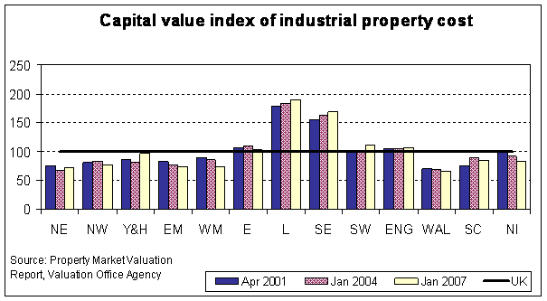
Chart 16(b)
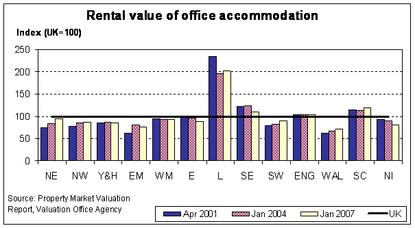
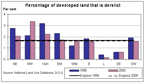
Table 17 provides estimates of the proportion of previously developed land that is derelict or vacant and the proportion of land that has potential for redevelopment. Chart 17 illustrates the proportion of derelict land in 1998 and 2004. For the definitions of vacant and derelict land refer to the Definitions section.
In 1998, Yorkshire and the Humber had the highest percentage of previously developed land that was vacant (3.1 per cent) in addition to the highest percentage of developed land that was derelict (3.2 per cent). By 2005, this pattern had changed, with the North East having the highest percentage of previously developed vacant land (at 2.8 per cent of total stock) and the North West the highest proportion of derelict land (3.4 per cent – an increase of 1.3 percentage points on the 1998 figure).
The lowest percentage of developed land left unused and/or derelict during both 1998 and 2005 was in London (around 1 per cent of the total stock during this time). The profile of land redevelopment for London is unsurprising, with commercial pressures driving up land values and speeding up the redevelopment of unused, derelict land.
Chart 17